Zoning and Land Use

The mission of the Zoning Program is to assist with the preparation and implementation of Comprehensive Land Use Planning and administer comprehensive zoning, shoreland overlay zoning, subdivision ordinance, private onsite sewage system ordinance and floodplain ordinance as well as related Wisconsin Administrative Codes. These ordinances regulate the uses of land (in county zoned towns) through a permitting process whereby applicants identify anticipated uses and structural setbacks and the zoning staff confirms their compliance with the applicable ordinances and codes. Such uses/items are regulated to maintain the health, safety and welfare of our citizenry as well as the integrity of our environment.
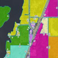
Lincoln County's Zoning authority only extends to the Towns who have adopted Lincoln County Zoning (shown in color in the map). Areas that are not shown in color are Towns who have not adopted Lincoln County Zoning. These “unzoned towns” are still subject to Lincoln County Shoreland Zoning. Shoreland Zoning includes all areas within 300 ft. of the ordinary high water mark of a stream/river or within 1000 ft of a lake.
All lands located within zoned towns (Bradley, Corning, Harding, King, Merrill, Russell, Schley, Scott, Skanawan, Tomahawk, and Wilson) are divided into zoning districts of such number and character as are necessary to achieve compatibility of land uses within each district, to implement the Lincoln County comprehensive plan and component town land use plans, and to achieve the other stated purposes of this the Lincoln county Zoning Ordinance.

A compiled list of permits and forms required by Lincoln County Zoning. If you have any questions, please call Zoning at 715-539-1087.

Lincoln County Shoreland Zoning regulations apply to areas of land within 300 feet of the Ordinary High Water Mark (OHWM) of navigable streams and rivers and areas of land within 1,000 feet of the OHWM of lakes and flowages. Shoreland Zoning regulations are intended to protect the long term health of the public’s shoreland resources and minimize pollution of navigable waterways in Lincoln County. These laws protect our water resources from uncontrolled use of the land which would adversely affect the public health, safety, convenience, and general welfare and impair the tax base.
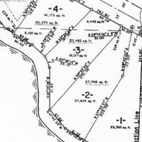
The Lincoln County Subdivision Ordinance governs the division of land into smaller parcels. This includes major and minor subdivisions of land, large lot splits, major and minor condominium plats, and certified survey maps (CSM).

Wetlands are landscapes which contain three distinct characteristics including saturated soils, hydrology, and hydric plant species. Wetlands are protected landscapes and activities such as filling, grading, and construction in wetlands are regulated by the Wisconsin Department of Natural Resources and The Army Corps of Engineers. Wetlands are nurseries for fish and wildlife, purifiers for lakes, rivers and groundwater, and storage for floodwaters.
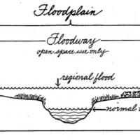
The Floodplain Zoning Ordinance regulates all areas that would be covered by the regional flood or base flood. Lincoln County has been issued official floodplain maps by the DNR and has adopted the Floodplain Zoning Ordinance to administer development within the mapped floodplain. As a consequence, citizens in the community become eligible to apply for Federal flood insurance.
The ordinance is intended to regulate floodplain development to:

Lincoln County, located at the south edge of Wisconsin’s Northwoods, is experiencing increased growth and development activity. This growth has potential positive impacts, if growth is properly planned. Unplanned development could, however, overwhelm Lincoln County’s rural character, which is highly valued by its residents.